Showing posts with label Manhattan. Show all posts

Monday, June 21, 2021

From the Archives: New York City in 1938

Envelopes containing negatives and contact prints, pre-1940
Dear Readers, you may remember that I recently experimented with film packs, in my case GAF Versapan in 4×5" size. I had little experience with this format, but early in the 20th century, various size film packs were common. Before 1939 or 1940, my dad used film packs for all his photography. He bought his first roll film camera, a 35mm Perfex, in 1941 or 1942.
Envelope containing processed negatives from Block-Jones Co., Boston, Massachusetts
He stored his negatives in the envelopes that came back from the processing laboratory or drugstore and neatly filed them in an office box. I recently decided to recheck the negatives. Looking through the envelopes, I saw one labeled "New York Nov. 1938." These negatives were 2¼×3¼ inch size (close to the 6×9 that is common today). I think these were from a Certosport or Certotrop camera. I recall using it a few times around 1970, but cannot remember what lens was on it. My photographic results were quite unsatisfactory, and the unit suffered from light leaks. Back then, you could still buy the small pack film. These 1928 sheets are all nitrate film stock.
Queen Mary SS Normandie with Ellis Island in distance, New York Harbor (scan of a toned contact print) 
Queen Mary SS Normandie and unknown dredge, New York Harbor (scan of portion of 2¼×3¼" negative)
The Battery, Manhattan (scan of contact print)

The Battery, Manhattan, New York (scan of of 2¼×3¼" negative)
My dad and his friends took a boat trip, possibly one of the circle-Manhattan excursions that are still popular. He was lucky to see the Queen Mary Normandie heading out to sea. At that time, the Normandie was the peak of luxury, sophistication, and glamour for those with the funds to travel abroad. Only a year later, the start of the Second World War ended most Europe-bound tourism.
View towards Central Park from Rockefeller Center
View towards East River (?) from Rockefeller Center
View SW towards Empire State Building from Rockefeller center
This group of night photographs may be from The Top of the Rock at 30 Rockefeller Plaza. According to Wikipedia
30 Rockefeller Plaza is an American Art Deco skyscraper that forms the centerpiece of Rockefeller Center in Midtown Manhattan, New York City. Completed in 1933, it was designed by Raymond Hood, Rockefeller Center's lead architect. 30 Rockefeller Center was formerly called the RCA Building from its opening to 1988, and later the GE Building from 1988 to 2015. It was renamed the Comcast Building in 2015, following the transfer of ownership to new corporate owner Comcast, though its name is often shortened to 30 Rock. 
In 1938, this was a glamorous example of American architectural and engineering excellence.
Prometheus Statue (1934)
This is the famous Prometheus statue, by sculpture Paul Manship, located in the lower plaza at Rockefeller Center.  "Prometheus, teacher in every art, brought the fire that hath proved to mortals a means to mighty ends."

This ends our short 1938 tour. I will slowly look for more New York negatives as I go through the box.

Appendix


The Model A shown in the catalog from Burleigh Brooks may be my dad's  Certo camera, but I just cannot remember.

Update: A reader alerted me that the ocean liner in the photographs above was the Normandie. He was right. I compared there profiles of the Queen Mary and the Normandie, and the vessel in the photographs is the latter. 

Saturday, April 23, 2016

From the archives: New York City in 1942

I recently looked through some family boxes of photographs and found a steel Kodak film can with tightly rolled film. It was a short roll of nitrate film, possibly untouched since it was developed in 1942. It recorded one of my dad's trips to Washington and New York City.
This is one of the Elevated (El) Lines, somewhere in Lower Manhattan.
The monumental building with a statue on top is the Municipal Building at 1 Centre Street. Built between 1907 and 1914, it houses City of New York offices. It may have been the inspiration for the Stalin-era Seven Sisters office buildings in Moscow. Warsaw also has one of these somber buildings, "donated" by Marshal Stalin to the supposedly-grateful people of occupied Poland. The tall building on the right is the Thurgood Marshall United States Courthouse at 40 Centre Street. It was originally known as the Foley Square Courthouse but was renamed in 2001 to honor Mr. Marshall.
The elegant Art Deco Cities Service Building, now known as 70 Pine Street, is 67 stories or 952 feet tall. It was built in 1931-32 by the Cities Service Company (oil and gas).
George Washington presides over the monumental stairs at the US Treasury building. This is now the Federal Hall National Memorial at 26 Wall Street. General Washington took his first Oath of Office here, and the building at one time housed the Congress, Supreme Court, and executive offices of the United States government.
Trinity Church is at 75 Broadway and can be seen at the end of Wall Street. This is the third Trinity Church on the site. Construction began in 1839 and it was completed in 1846.
Slightly off the topic: this is Memorial Continental Hall, owned & operated by the Daughters of the American Revolution, in Washington, DC.

To the best of my knowledge, this roll of film dates to early 1942, but my dad's notes are incomplete. The camera was an American-made Perfex, from the Candid Camera Corporation of Chicago. It may have been equipped with a Wollensak lens. I scanned the Nitrate film frames with a Plustek 7600i 35mm film scanner using SilverFast Ai software. The negatives have scratches, but unfortunately the infrared iSRD function does not work with real black and white film. Consider that despite the flaws, there is still data on this film that can be extracted 64 years later. Will our digital files last that long? (Answer, dream away.)
This is a 1996 Kodachrome photograph of the Thurgood Marshall Courthouse. I think I was on the roof of an office building occupied by the State of New York's Department of State at 270 Broadway. This file came from a Kodak Photo CD, which was an early attempt to provide a convenient way to show photographs on a television set. A film laboratory developed the film and then scanned the frames onto a CD. The user could insert the CD into a small player, somewhat like a VCR player. The scans technically should have been excellent, but my experience was mixed. Some contractors did distinctly mediocre work. Now, it is difficult to find a software package to open the proprietary Kodak format.

Saturday, September 3, 2011

New York and the World Trade Center: the Late Years and Destruction

This is the second of a two-part series on my memories of New York City and the World Trade Center.
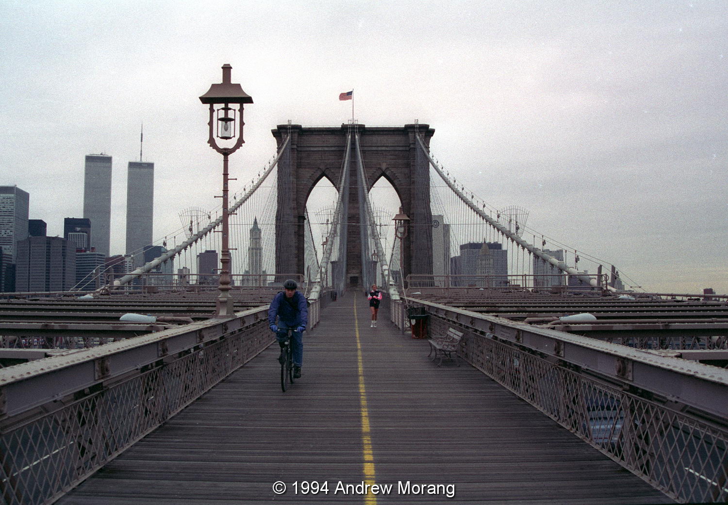
Brooklyn Bridge pedestrian walkway
Right half of undated stereo card of Brooklyn Bridge, from  the Boston Public Library digital archives
After visiting New York in the early 1970s, ten years passed before I returned. I recall a snowy stop-over in 1982, but did not make it to lower Manhattan that time. A decade later, professional duties took me to the Big Apple three or four times per year. I really enjoyed these trips; the people were nice, food great, and there was always something interesting to see or do. On 1994, after a long, dull day of meetings, I decided to clear my brain and walk across the Brooklyn Bridge. It's a great walk on a brisk day, and the view is spectacular, but the ambiance is marred by the constant traffic directly below the walking deck. This first photograph shows the view looking west while walking from Brooklyn to Manhattan. The twin towers are off to the left (south) of the bridge axis.
The second photograph shows the view north, with the Empire State Building beyond the historic Manhattan Bridge (opened to traffic on December 31, 1909). These were taken with Kodak Gold 100 film, which worked well on gloomy days and scans well.
In 1995, the family and I stayed in the Vista International Hotel at 3 World Trade Center. It was a 22-story steel-framed building, said to be the first hotel to open in Lower Manhattan since 1836 (is this possible?). It was badly damaged by the truck bomb that terrorists set off in the underground parking garage in 1993, but had been renovated and reopened. The hotel was convenient because you could pass through enclosed walkways into the lobbies of the north and south Trade Center towers. I recall one of the lobbies had a ticket office where you could buy half-price tickets for Broadway and off-Broadway productions. One evening, we went to the top floor of the hotel, and one of the stairways had an unlocked access door to the roof. The view of the south tower was awesome. It loomed up into the foggy night sky seemingly forever. Some employees were toiling away late in their offices. On September 11, the hotel was almost totally crushed, and 40 people lost their lives.
In 1997, I attended a meeting in a NY State Department of State office building at 212 Broadway. The meeting was on the top floor, and once again, an access door to the roof was unlocked. This was too good to resist and I took a panorama of the World Trade Center building using a 35 mm Olympus shift lens (in this case, shifting the lens vertically).
Panorama of four Rolleiflex exposures on 120-size film.
On April 29, 2001, I spent another day in meetings. It was a gorgeous clear day, and when I escaped, there were still two hours of daylight left. I had never been to the rooftop observation deck, and this was a perfect chance. Although being quite expensive, I recall thinking I might not have another opportunity. The Top of the World observation deck was on the 107th floor of 2 World Trade Center (the South Tower), and stairs went up to the open roof (open only on calm days). Amazingly, there was absolutely no wind that afternoon. Tourists from Germany and other countries were taking self-portraits with the spectacular view of Manhattan in the background (I confess, I took the obligatory dorky picture, too). The panorama looking north and east shows the north tower and Manhattan spread out across the horizon. The metal frame at the lower right is the rail system for the window-washing machines. The tourist gallery was set back, and you could not look down at a steep angle and see the streets immediately below. The panorama consists of four Rolleiflex (120-size film) frames merged together. Being a large film size, the original prints contain an astonishing amount of detail.
Card by Mayor Rudi Giuliana, from the Leica Gallery
Mayor Rudi Giuliani was a talented Leica photographer. I saw a sign at the Leica Gallery that the mayor always took his Leica with him when he made rounds around the city.
Federal Plaza from World Trade Center, April 29, 2001
Antennas and equipment on the roof of the North Tower, April 29, 2001
The view of Federal Plaza shows the amazing vista from the enclosed Top of the World observation level. The banal rectangle building in the center is the Jacob Javits Federal Building. The 1913-vintage Woolworth Building at 233 Broadway is in the lower right. The tall windowless red/brown edifice to the left is the former AT&T Long Lines Building. According to Wikipedia, it was designed to be self-sufficient and protected from nuclear fallout for up to two weeks after a nuclear blast. The East River is in the background.

Then the unimaginable happened. Five months after visiting the observation deck, the towers were destroyed. My coworkers and I watched television in our Vicksburg office transfixed as we saw the towers implode and throw up an immense dust cloud.
NASA photograph iss003e5388_232021.
This amazing NASA photograph from the International Space Station, taken by astronaut Frank Culberston, shows the dust plume rising into a clear sky (photograph iss003e5388_232021).

The next time I had business in New York was on December 19, 2001. Work crews had already cleared out an amazing amount of the rubble and twisted metal, but as the photographs show, some gutted buildings were still standing. I could not enter the demolition site, but the views past the truck entrances were horrifying. Two of my coworkers told me that was the first day they did not smell fumes from the underground fires. Before then, fumes were sucked into the ventilation system of the Jacob Javits Federal building, causing severe headaches for some workers.
This was the remains of the Winter Garden, across West Street from the Trade Center Plaza. It once housed beautiful palm trees.
Very moving were the impromptu memorials of flowers, notes, letters, and photographs of loved ones who had perished. Fortunately, none of my coworkers were hurt, but all knew someone or were connected via a friend or neighbor to someone who died.
MTA route map, December 2001
The December 2001 MTA route map shows how four subway stations were out of commission after the disaster. The WTC station was destroyed and had to be rebuilt.

I took the black and white photographs with Kodak CN400 film using my 1949-vintage Leica IIIC camera with a 5 cm Æ’/3.5 Red Dot Elmar lens. This was the post-war coated version of the famous Elmar lens, in production until the 1960s. This, as well as the later Æ’/2.8 version, are wonderful performers when adapted to Leica, Micro 4/3, or Fuji X digital cameras (and, of course, are best on film). My IIIC is still in regular use, but I sold the Red Dot Elmar lens.

Updated August 15, 2014, with added photograph.
Updated October 2018: added MTA map.
Update March 12, 2020: Mr Michael Hertz, whose design studio created the iconic NY Transit Map, died on February 28, 2020.
Update July 12, 2020: Added early-1900s stereo card of the Brooklyn Bridge

Tuesday, August 30, 2011

New York and the World Trade Center: The Early Years

Introduction

Ten years ago, on September 11, 2001, terrorists flew two fuel-laden jet planes into the World Trade Center towers in New York City, causing their collapse, killing thousands, and changing history. The destruction led to two foreign wars, an enormous increase in the security apparatus in the United States, stunning increases in the military-industrial complex, and myriad changes in the ways we view ourselves and the world around us. In many ways, we lost our way and lost the moral high ground internationally. To commemorate the terrible events of ten years ago, I looked through my archives to find photographs of the towers and other memories of New York. Although I did not live in New York during the years that the towers stood, I saw them on visits to the city, shopped in the underground malls, and once went up to the open observation deck.

Pre-tower Manhattan


This is a map of lower Manhattan from a brochure given out to tourists who visited the Towers in the 1990s. The towers were on the southwest corner of Manhattan. They did not directly face the Hudson River, but the site they were on was artificial fill. The scale of this map is off and the Liberty Island is really much further away.

Early 20th century map of Manhattan with steamship company docks along the Hudson River.

First, let's step back in history to well before the towers were built. The scene above shows upper New York Harbor and Manhattan Island at about 1940. The original photograph is from the archives of the Beach Erosion Board, U.S. Army Corps of Engineers. The archives are now housed at the Coastal and Hydraulics Laboratory at the Waterways Experiment Station in Vicksburg, Mississippi. Notice how the Hudson River (on the left) is lined with docks and wharves.

In 1940, New York and Jersey City were gritty, bustling working cities and ports. If 1940 is the correct date, war was raging in Europe, and New York harbor was a major transit origin for cargo convoys. Most of Europe was shrouded in darkness, but New York was a beacon of freedom for the few refugees who could find transit to the United States. Lights were blazing, food was plentiful, shops were stocked, and music and entertainment were everywhere - war seemed far away. The site for the towers was on the lower left side of Manhattan, then a district of small shops, factories and residences, known as Radio Row. The George Washington Bridge, completed in 1931, crosses the Hudson in the upper left of the photograph.

The island off the tip of Manhattan is Governors Island, occupied by the Coast Guard for most of the 20th century and now run by the National Park Service and the Governors Island Alliance. In the late 1930s, Robert Moses (Long Island Park Commission) pushed to build a monumental bridge connecting Manhattan to Brooklyn, with one of the bridge supports on Governors Island. Moses had such influence and control of funding sources that only President Franklin Roosevelt was able to squash the plan.

Liberty Island, with its Statue of Liberty, is the small island on the lower left, really much closer to the New Jersey shore than to New York.

The 1960s


Let's move forward to 1967. I took the photograph above from Rockefeller Center, probably from the observation deck in the GE Building, the Top of the Rock. Looking south you see the Empire State Building. If they had been built, the WTC towers would have been in the far distance to the right of the Empire.

This is the former PanAm building, built over the railroad lines leading into Grand Central Station. Back then, First Class passengers on Pan American World Airways were ferried to JFK airport by helicopter that took off from the rooftop heliport. This is a Boeing Vertol BV-107 helicopter (also known as a Sea Knight), operated by New York Airways. The heliport was permanently closed after a 1977 accident, where a broken rotor blade decapitated four passengers.


A side note: 1967 was near the end of the era of trans-Atlantic passenger traffic via ocean liner. The 1940 photograph showed how the entire Hudson River shore of Manhattan was lined with docks. But by the late-1960s, many of the docks were unused and passenger traffic on the great liners was drying up. This was largely a result of the success of the Boeing 707 jet liner, which entered service in 1958. The post-war generation was impatient and did not want to spend six days crossing the ocean (but I am glad that I made two Atlantic ship crossings in my childhood - they were fun). I took the photographs of the S.S. Constitution and the docks on color print film with a Canon range-finder camera and 50mm Æ’/1.9 Serenar lens.

The 1970s


The Port Authority of New York and New Jersey built the twin WTC towers between 1996 and 1972. The matching buildings, designed by American architect Minoru Yamasaki, rose to 1353 feet (412 m) in height. When completed in 1972, they were the tallest buildings in the world. A Wikipedia article nicely summarizes their history and the decades of controversy and sordid political maneuvering surrounding the project. The aesthetics of the design were resoundingly criticized at the time and for many years later as extreme examples of post-war gigantism, but eventually they became icons of New York. The undated post card above, from Golden Apple Postcards, shows the towers taken with a long telephoto lens from the waterfront at Bayonne, New Jersey. Unfortunately, the photographer was not credited.


In March, 1974, I made a one-day trip to New York and took the excursion boat to Liberty Island. The South Tower had only been open two years and both towers were were only partly occupied. Attracting commercial (as opposed to subsidized Port Authority) tenants was part of the controversy that continued for years. From this vantage point, it was obvious how huge the buildings were, looming over everything else in lower Manhattan.


This is a 105mm tele view of the towers, scanned from a roll of Kodak Tri-X black and white film. This negative was double-exposed, adding to the dust and flaws in the frame. Still, after 35 years, the negative is intact and contains data that can be extracted. Will we be able to retrieve digital media in 35 years? (Camera: Nikkormat FTn; lens: 105 mm Æ’/2.5 Nikkor.)

Update May 6, 2013

I found this remarkable aerial photograph in NOAA's archives of a flying boat cruising over Battery Park. The Hudson River is in the foreground, the East River in the background. As in the 1940 photograph, you can see the many docks lining the rivers.


The label states:
A flying boat cruising by Battery Park at the south end of Manhattan Island. In: "Flug Und Wolken", Manfred Curry, Verlag F. Bruckmann, Munchen, 1932.
Image ID: line0987, NOAA's America's Coastlines Collection
Location: New York City
Photo Date: 1930 Circa
Credit: Fairchild Aerial Surveys Inc.
(To be continued in the next article.)
Updated with two photographs added on August 15, 2014